Da Nang City is one of the best places in the Middle land of Vietnam. That is an ideal destination for enjoying a wonderful time on the tops of the mountains, inside the jungles or beside the rivers or beaches.
Da Nang City

The elongated oval of Da Nang occupies a small headland protruding into the southern curve of Da Nang Bay.
The city faces east, fronting onto Bach Dang and the Han River, across which the narrow Son Tra Peninsula shelters it from the South China Sea. Its streets follow a rough grid plan, dissected by two main thoroughfares, Le Duan and Le Loi/Phan Chu Trinh. Hung Vuong and streets around form the commercial heart of Da Nang, running between the two central markets: sprawling, oppressive Cho Con in the west and orderly Cho Han by the river.
Two blocks south of Han market, past the soft, salmon-mousse coloured cathedral, colonial Da Nang is represented by a few wooden and stucco houses at the eastern end of Tran Quoc Toan. From here turn right along riverfront Bach Dang for 750m to reach the Cham Museum, the city’s only real tourist attraction, or left to stroll north past a collection of well-restored French-era administrative buildings, some of them now occupied by People’s Committees and hotels.
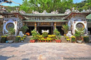
The Cham Museum

Even if you’re just passing through Da Nang, try to spare an hour for the small Cham Museum at 2 Duong 2 Thang 9 (7am–5pm; 30,000đ), particularly if you plan to visit the Cham ruins at My Son.
The museum – whose design incorporates Cham motifs – sits in a garden of frangipani trees at the south end of Bach Dang, and its display of graceful, sometimes severe, terracotta and sandstone figures gives a tantalizing glimpse of an artistically inspired culture that ruled most of southern Vietnam for a thousand years. In the late nineteenth century French archeologists started collecting statues, friezes and altars from once magnificent Cham sites dotted around the hinterland of Da Nang, and opened the museum in 1916. Though this is undoubtedly the most comprehensive display of Cham art in the world, it’s said many of the best statues were carried off into European private collections.
Recurring images in Cham art are lions, elephants and Hindu deities, predominantly Shiva (founder and defender of Champa) expressed either as a vigorous, full-lipped man or as a lingam, but Vishnu, Garuda, Ganesha and Nandi the bull are also portrayed. Buddhas feature strongly in the ninth-century art of Indrapura, a period when Khmer and Indonesian influences were gradually assimilated. The most distinctive icon is Uroja, a breast and nipple that represents the universal “mother” of Cham kings.
As the Viets pushed south during the eleventh century, so the Chams retreated, and their sculptures evolved a bold, cubic style. Though less refined than earlier works, the chunky mythical animals from this period retain pleasing solidity and a playful charm.
The exhibits are grouped according to their place of origin and are positioned in two main halls. In the first hall, a massive, square altar pedestal (late seventh century) from the religious centre of My Son is considered a masterpiece of early Cham craftsmanship, particularly its frieze depicting jaunty dancing-girls, and a soulful flute player. However, experts and amateurs alike usually nominate two lithe dancers with Mona Lisa smiles, their soft, round bodies seemingly clad in nothing but strings of pearls, as the zenith of Cham artistry. The piece also features two musicians on a fragment of capital produced by Tra Kieu sculptors in the late tenth century, just before the decline of the Champa kingdom.
The second hall is a new extension at the back; three times larger than the first hall, it includes a further 146 stone sculptures, dating from the seventh to the fourteenth centuries.
Da Nang cathedral

Known to locals as Con Ga Church (Rooster Church) because of the weathercock on top of the steeple, the candy-pink Danang Cathedral (Ð Tran Phu) was built for the city’s French residents in 1923.
Today it serves a Catholic community of 4000 – it’s standing room only if you arrive late. Mass is usually held from Monday to Saturday at 5am and 5.30pm, and on Sunday at 5am, 6.15am, 7.30am, 3.30pm and 5pm.
Han River bridge
Nature has been awarded the Da Nang good for a city to stay and to enjoy the healthy fun. Han river as background for the series along streets, and always bring cool wind and moisture to propitiate the tropical sunshine.
Danang lies on the west side of the Han River and the beaches are to the east. The Song Han Bridge helps beach driven tourists to get from their hotels to the area`s famous beaches.

In the middle of the night, traffic is stopped from crossing the Song Han Bridge and it swings on its axis to allow shipping traffic to pass along the river. The Song Han Bridge in Danang is a suspension bridge that is dazzlingly lit up at night. The area around the bridge is beautifully paved into a riverside promenade and is the location of Danang`s cultural center.
Some of the pressure will soon be taken off the bridge as the Danang regional government plans to build another bridge to traverse the Han River in Danang. Once the new bridge is completed tourists will be able to leave Da Nang International Airport on Nguyen Van Linh Highway and get to the city`s beaches even quicker. The new bridge will be built in the shape of a dragon.
The Song Han Bridge was built by the people of Danang and holds a special place in their pride for their city. The bridge also has the distinction of being the first swing bridge to be built in Vietnam. The bridge is an important part of Danang`s cityscape.
Son Tra Peninsula

Quite pretty and with a good bit of naturalness, Son Tra Peninsula is a good place for visitors to Da Nang and get away for the day.
Son Tra Peninsula is 10km from the center of Da Nang City to the North-east and is 693m high above sea level. Son Tra Mountain can be seen from every places of the city. Son Tra looks like a mushroom of which cap is Son Tra Mountain and stalk is a beautiful sandy beach that affords an ideal area for bathing, playing sports, fishing and swimming.
With its sea-oriented appearance, Son Tra acts as a giant screen protecting Da Nang from storms and cyclones coming from the sea. Son Tra is put under the national protected forest regulation since it is a natural preservation area. The Peninsula is famous for its plentiful plants and fauna as well as the attractive scenery. It is said that fairies used to come here for singing, dancing and playing chess so Son Tra is also called Tien Sa (Fairies’ landing place). On this mountain, there still remain more than 30km² of natural forests, nearly 300 types of plants and several hundred kinds of fauna, including rare animal. From the top of the mountain, you can see the overall view of Da Nang City, Marble Mountains, Ba Na Hill – Mount Chua, so interesting!
Suoi Da (Stone Stream) lies by the side of the foot of the mountain, fine sandy surfaces run round the peninsula, several breaks of waves are running steadily up and down and washing up on the stones heaped up around the seaside. All are attractive spots for tourists. It is so majestic and it is so romantic, it is so wide and it is really beautiful. In one-day stay at Son Tra, visitors can enjoy living in the resplendent flow of dawn and the quietness of twilight on this fascinating landscape. And that is a time for them to realize the value of each and every moment and the true calling of the hearts. You can also swim in the cool sea and enjoy the fine view of the sandy banks run round the peninsula. The quiet Bai But offers you relaxing times sitting in small nice houses to hear the sound of waves and look swallows fly to the mount cliffs. The colorful coral reefs at the foot of the mountain are an ideal condition for the development of diving tourism.
Son Tra is a special gift of the god to Danang. It can be seen from every places of the city. And from the top of the mountain, the vista is so enjoyable and peaceful…
Nui Son Tra (Monkey Mountain)

Jutting out into the sea like a giant pair of Mickey Mouse ears, the Son Tra peninsula is crowned by the mountain that the American soldiers called Monkey.
Grandly overlooking Danang to the south and the Hai Van Pass to the north, it was a prized radar and communications base during the war. Today it’s still largely undeveloped except for Tien Sa Port (Cang Tien Sa) on its eastern tip, although that may change soon with road construction and talk of beach resorts.
The highlight of visiting Monkey Mountain is the views from the summit, which are stupendous on a clear day. Most of the mountain used to be off-limits to tourists, but the Vietnamese military has gradually loosened its hold and it’s possible to take your own vehicle up to the top. What remains of the American military presence are a couple of radar domes (still used by the Vietnamese military and a no-go for tourists) next to a helicopter pad, now a lookout point. The steep road to the summit is pretty deserted and road conditions can be iffy. If you’re going on motorbike, you’ll need a powerful one to make it to the top. The turn-off to this road is about 3km before Tien Sa Port and marked by a blue sign that reads ‘Son Tra Eco-tourism’.
Most Vietnamese who come here head to one of the beach resorts along the peninsula’s southwestern coast or to sheltered Tien Sa Beach (Map) beside the port. Neither of these is quite as nice as China Beach (opposite), but that hasn’t stopped developers from breaking ground for new resorts. A road is also being built to circumnavigate the peninsula, which when completed would make for an incredibly scenic drive.
A memorial near the port commemorates an unfortunate episode of colonial history. Spanish-led Filipino and French troops attacked Danang in August 1858, ostensibly to end Emperor Tu Duc’s mistreatment of Catholics. The city quickly fell, but the invaders were hit by cholera, dysentery, scurvy, typhus and mysterious fevers. By the summer of 1859, the number of invaders who had died of illness was 20 times the number who had been killed in combat.
Many of the tombs of Spanish and French soldiers (Map; admission free) are below a chapel near Tien Sa Port. To get here, cross Song Han Bridge and turn left onto Ð Ngo Quyen, continuing north to the port. The overgrown ossuary, a small white building, stands on the right on a low hill, about 500m before the port’s gate.
Non Nuoc Beach

Follow the paved road east from Non Nuoc Village for about 500m, round a dogleg, and you reach Non Nuoc Beach, promoted locally as “new China Beach”.
Huge, empty and consisting of clean, fine white sand, it’s far enough from Da Nang to leave you unpestered. There’s a cluster of cafés, restaurants and souvenir stalls beside the car park….
Those looking for something more modest should head back to the dogleg and turn down towards the beach on Huyen Tran Cong Chau to find a warm welcome at Hoa’s Place (0511/396 9216, hoasplace@hotmail.com; US$10 and under), a delightfully laidback guesthouse offering twenty clean, good-value rooms. It has built up a cult reputation with backpackers and surfers, some guests staying for months. They also lay on very reasonably priced and convivial meals and can arrange motorbike rental or a xe om to Hoi An or Da Nang.
Marble Mountains

A spectacular sight from the China Beach coastal road, Marble Mountains (Ngu Hanh Son) consists of five craggy marble outcrops topped with delicate pagodas.
Each mountain is named for the natural element it’s said to represent: Thuy Son (Water), Moc Son (Wood), Hoa Son (Fire), Kim Son (Metal or Gold) and Tho Son (Earth). The villages that have sprung up at the base of the mountains specialise in marble sculpture, though they now astutely use marble from China rather than hacking away at the mountains that bring the visitors (and buyers) in.
Thuy Son (admission 15,000d; 7am-5pm) is the largest and most famous of the five mountains, with a number of natural caves in which first Hindu and later Buddhist sanctuaries have been built over the centuries. Of the two paths heading up the mountain, the one closer to the beach (at the end of the village) makes for a better circuit.
At the top of the staircase is a gate, Ong Chon, which is pockmarked with bullet holes. This leads to Linh Ong Pagoda. Behind it, a path heads left through two short tunnels to several caverns known as Tang Chon Dong, containing several Buddhas and blocks of carved stone of Cham origin. Near one of the altars is a flight of steps leading up to another cave, partially open to the sky, with two seated Buddhas in it.
Immediately to the left as you enter Ong Chon Gate is the main path to the rest of Thuy Son, beginning with Xa Loi Pagoda, a beautiful stone tower that overlooks the coast. Stairs off the main pathway lead to Vong Hai Da, a viewing point that would yield a brilliant panorama of China Beach if it weren’t so untended. The stone-paved path continues to the right and into a canyon. On the left is Van Thong Cave, opposite which is a cement Buddha and a narrow passage that leads up to a natural chimney open to the sky.
Exit the canyon through a battle-scarred masonry gate. There’s a rocky path to the right leading to Linh Nham, a tall chimney-shaped cave with a small altar inside. Nearby, another path leads to Hoa Nghiem, a shallow cave with a Buddha. If you go down the passageway to the left of the Buddha, you come to cathedral-like Huyen Khong Cave, lit by an opening to the sky. The entrance to this spectacular chamber is guarded by two administrative mandarins (to the left of the doorway) and two military mandarins (to the right).
Scattered about the cave are Buddhist and Confucian shrines; note the inscriptions carved into the stone walls. On the right a door leads to two stalactites, dripping water that comes from heaven, according to local legend. Actually, only one stalactite drips; the other one supposedly ran dry when Emperor Tu Duc touched it. During the American War this chamber was used as a VC field hospital. Inside is a plaque dedicated to the Women’s Artillery Group, which destroyed 19 US aircraft from a base below the mountains in 1972.
Back on the main path, just to the left of the masonry gate is Tam Thai Tu Pagoda, restored by Emperor Minh Mang in 1826. A path heading obliquely to the right goes to the monks’ residence, but before you reach it, take the stairs to the left of the path to Vong Giang Dai, which offers a fantastic 180-degree landward view of the other Marble Mountains and their surroundings.
A torch (flashlight) is handy but not essential for exploring the caves. The gradient of the walk is quite comfortable, but whichever end you start at, the ascent up the mountain begins with a fairly strenuous climb. Local buses between Danang and Hoi An (tickets 10,000d) can drop you at Marble Mountains, 19km north of Hoi An.
Ba Na Hill Station

Perched 1500m up a mountain 48km west of Da Nang, Ba Na Hill Station provides a welcome change from the coast.
The site was first developed by the French in the 1920s, who escaped the summer heat for its cool, mountain air. After a brief heyday in the 1930s the resort was abandoned and soon fell victim to the ravages of war and the encroaching jungle. Thanks to a high annual rainfall together with temperatures at a constant 17–20°C, dense forest growth cloaks the mountain, which is home to over five hundred species of flora and 250 of fauna. In the past few years the local authorities have poured money into Ba Na, converting some of the old French villas into guesthouses and restaurants, laying forest trails and a new access road and even putting in a cable car – a great hit with the locals, who come up here at night to admire the lights of Da Nang twinkling far below. Not that the daytime views are to be scoffed at, taking in the Hai Van Pass, Son Tra Peninsula and Marble Mountains if you’re lucky. Given the weather, you may have to content yourself with a more atmospheric scene of mountains wreathed in mist, but while it’s raining on the lower slopes, the summit may be above the clouds, enjoying brilliant sunshine.
Views apart, the main attraction is exploring the forest paths and wandering among the ruined villas, for which half a day will suffice. You may want to avoid summer weekends when the place can be packed out. A return trip by car or xe om from Da Nang will be pricey once waiting time is factored in – bargain hard – but Da Nang tour agents (see “Around Da Nang”) also offer various organized bus tours, mostly in summer.
Lang Co Beach

Descending again into warmer air, a white-tipped spit of land comes into view round a hairpin bend, jutting into an aquamarine lagoon strung with fishing nets.
Sadly, this much photographed scene is marred by the road bridge marching across it. The original bridge spanning the lagoon has the dubious distinction of being the Viet Minh bomb squads’ first target in 1947 and its ruined piles are still visible. LANG CO village hides among coconut palms on the sandy peninsula, its presence revealed only by a white-spired church. It makes a popular lunch stop on the road between Da Nang and Hué, though a quick swim from the narrow beach will be spoilt by electricity pylons and a good deal of rubbish – head north away from the fishing village to find cleaner sand.
Lang Co has been earmarked for tourist development for years, yet it remains rather quiet, with only a few beach resorts in operation and a number of cheaper guesthouses on the other side of the highway. If you decide to stay, the best all-round option is Thanh Tam (054/387 4456; US$21–30), on the highway about 1500m north of the village; ask for a sea view. On the opposite side of the highway, Anh Nguyen (054/387 4448; US$11–20) has nice en-suite rooms with hot water, while nearby Chi Na (054/387 4597; US$10 and under) is another friendly place with a handful of simple but clean rooms at slightly cheaper rates. The government-owned Lang Co Beach Resort (054/387 3555, langco@dng.vnv.vn; US$31–50), opposite Chi Na, stands out a bit with its complex of green-roofed, Hué-style villas, landscaped pool and replica covered bridge. The rooms are big, light and well equipped and the beach here is kept scrupulously clean. Most of these places have restaurants, or will at least rustle up a meal, but the most popular place in town is Sao Bien just over the bridge when coming from the south, which busily serves an array of seafood to passing tour buses.
Lang Co lies about 40km north of Da Nang and 65km from Hué. The train station is on the lagoon’s western side, or public buses will drop you off anywhere on the highway. Sinh Café open-tour buses stop at Thanh Tam, while An Phu Tourist uses the very run-down Tourist Hotel towards the southern end of the strip.
My Khe beach

Just across the Song Han Bridge (10,000d by xe om), My Khe is fast becoming Danang’s easternmost suburb. In the early morning and evening the beach fills up with city folk doing t’ai chi.
Tourists emerge during peak suntanning hours, while locals start showing up in the evening. After dark the deckchairs are taken over by young couples seeking a little privacy. Despite its popularity, the beach is still blessedly free of roaming vendors and the only thing you might be coaxed to purchase is time on a lounger (15,000d).
The water has a dangerous undertow, especially in winter. However, it’s protected by the bulk of Nui Son Tra and is safer than the rest of China Beach.
This was the part of China Beach well known to American servicemen, and unfortunately a sleazy undertone lingers in parts.
October 17, 2018
December 23, 2018

May 8, 2018
March 29, 2018
September 22, 2019

June 3, 2019